The DJI M300RTK with DJI P1: Revolutionizing Aerial Surveying and Mapping
Aerial surveying and mapping have become essential tools in various industries, from construction and agriculture to environmental monitoring and infrastructure development. The advancements in drone technology have significantly improved the efficiency and accuracy of these processes. One such groundbreaking innovation is the DJI M300RTK with DJI P1 camera, a powerful combination that has revolutionised the way professionals conduct aerial surveys and mapping.
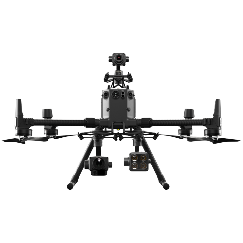
The DJI M300RTK: Unmatched Performance and Reliability
The DJI M300RTK is a professional-grade drone designed for industrial and enterprise applications. It boasts an array of advanced features that make it a game-changer in the field of aerial surveying and mapping. Here are some key features that set the M300RTK apart:
Advanced Flight Performance: The M300RTK is equipped with a robust propulsion system that allows it to fly in harsh weather conditions and withstand strong winds. Its maximum flight time of up to 55 minutes ensures extended coverage and reduces the need for frequent battery changes.
Precision Positioning: With the built-in RTK module, the M300RTK achieves centimeter-level positioning accuracy, enabling precise mapping and surveying. This feature is particularly crucial for applications that require high levels of accuracy, such as land surveying and infrastructure inspection.
Enhanced Safety: Safety is a top priority when operating drones, especially in complex environments. The M300RTK incorporates an advanced obstacle avoidance system that uses multiple sensors and AI algorithms to detect and avoid obstacles in real-time. This ensures safe and reliable operation, even in challenging conditions.
Extended Range: The M300RTK has an impressive transmission range of up to 15 kilometers, allowing operators to cover large areas without the need for multiple takeoffs and landings. This not only saves time but also improves overall efficiency.
The DJI P1: High-Resolution Imaging for Unparalleled Detail
The DJI P1 is a professional-grade camera specifically designed for aerial surveying and mapping. It combines a high-resolution sensor with advanced imaging capabilities to capture detailed and accurate data. Here are some key features of the DJI P1:
45-Megapixel Full-Frame Sensor: The P1’s large full-frame sensor captures images with exceptional detail and clarity. This high resolution allows for precise mapping and analysis, making it ideal for applications such as land surveying, urban planning, and environmental monitoring.
Global Mechanical Shutter: The P1’s mechanical shutter eliminates rolling shutter distortion, ensuring accurate and distortion-free images. This is particularly important when capturing images of fast-moving objects or when conducting photogrammetry.
TimeSync 2.0: The P1 is equipped with TimeSync 2.0, DJI’s synchronization technology that aligns the camera, flight controller, and RTK module. This synchronization ensures accurate geotagging of images, simplifying the post-processing workflow and improving overall data accuracy.
Smart Oblique Capture: The P1’s smart oblique capture feature allows it to capture images at different angles, providing a comprehensive view of the surveyed area. This enables professionals to generate detailed 3D models and perform accurate volumetric calculations.
Real-World Applications
The DJI M300RTK with DJI P1 has a wide range of applications across various industries. Let’s explore some real-world examples of how this powerful combination is transforming aerial surveying and mapping:
Construction and Infrastructure Development
In the construction industry, the M300RTK with P1 is used for site planning, progress monitoring, and quality control. By capturing high-resolution images and generating accurate 3D models, professionals can identify potential issues, track project progress, and ensure compliance with design specifications. This improves efficiency, reduces costs, and minimizes rework.
Agriculture and Environmental Monitoring
In agriculture, the M300RTK with P1 is used for crop monitoring, yield estimation, and disease detection. By capturing detailed aerial images, farmers can identify areas of concern, optimise irrigation and fertilisation, and make informed decisions to maximise crop yield. Similarly, in environmental monitoring, this powerful combination enables professionals to assess vegetation health, monitor wildlife habitats, and detect changes in land cover.
Land Surveying and Mapping
The M300RTK with P1 is a game-changer in the field of land surveying and mapping. Its high-precision positioning and high-resolution imaging capabilities allow professionals to create accurate topographic maps, conduct boundary surveys, and perform volumetric calculations. This is invaluable in urban planning, infrastructure development, and land management.
EMLID RS2 GPS Stations
Embrace the Future of Aerial Surveying and Mapping
The DJI M300RTK with DJI P1 is a groundbreaking combination that has huge implications for aerial photogrammetry surveying and mapping. Its advanced features, unmatched performance, and high-resolution imaging capabilities make it an indispensable tool for professionals across various industries. Whether you’re in construction, agriculture, or environmental monitoring, embracing this technology will undoubtedly enhance your efficiency, accuracy, and decision-making capabilities.
#2DMapping #3dModelling #Inspections #Mapping #photogrammetry #surveying
https://www.dronemediaimaging.co.uk/survey-grade-photogrammetry-equipment-with-dji-m300rtk-and-dji-p1-camera/
Comments